By car, cycle or on foot
There are several well marked walking trails crossing the area including the Hadrians Wall Path which runs East from Bowness on Solway and the Cumbria Coastal Path which follows the Solway coast shoreline, a landscape designated as an Area of Outstanding Natural Beauty (AONB)
- For other ideas on walking routes in the area visit the things to do section of the website.
A good network of roads traverse the Solway Plain. Follow the picturesque coast road from Carlisle west through Burgh-by-Sands, Drumburgh and Bowness and around the Cardurnock peninsula for some stunning views and characteristic Solway villages. Take the B5302 road from Wigton to pass Holme Cultram Abbey, ending up at Silloth for some fine Solway seaside air and an ice cream. Take the B5307 from Carlisleto Kirkbride to pass Finglandrigg Wood, and eventually, beyond Kirkbride, Wedholme Flow.
Many minor roads criss-cross the Solway and are waiting to be explored. Many of these are age-old and allow a real glimpse into a traditional farming landscape, and are especially appealing if you are on a bike. Be warned- some of these can be narrow or muddy, and it’s always a good idea to have a road map or ordnance survey map so you know where you’re going to end up.
Rail
There are train stations at Wigton and Carlisle, from where a number of bus routes can transport you throughout the area.
Bus
Several bus routes can take you out into the Solway landscape. A couple of suggestions are:
Travel from along the coast from Carlisle to Bowness stopping off at Burgh-by-Sands, Drumburgh and Bowness. Or take a 2km walk along the shoreline west of Bowness to get to the new Solway Wetlands Centre at RSPB’s Campfield Marsh reserve.
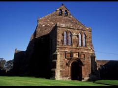
This bus will take you into the heart of the Solway Plain. From here visit any of a number of National Nature Reserves, or Holme Cultram Abbey at Abbeytown.
